Improved three-week weather forecasts could save lives from disaster
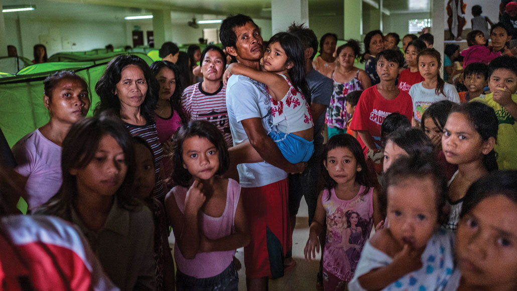
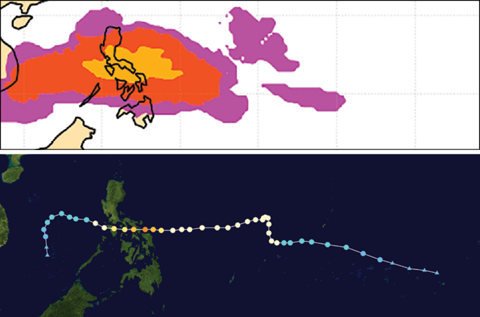
Weather forecasters in the Philippines got the tip-off in the second week of November 2019. A precipitation forecast that peered further into the future than usual warned that the islands faced torrential rains more than three weeks away. The meteorologists alerted local and national governments, which sprang into action. Mobile phone and broadcast alerts advised people to prepare to evacuate.
By the time the Category 4 Typhoon Kammuri lashed the Philippines with heavy rains in early December, the damage was much less than it could have been. Having so much time to prepare was key, says Andrew Robertson, a climate scientist at Columbia University’s International Research Institute for Climate and Society in Palisades, N.Y. “It’s a great example of how far we’ve come” in weather forecasting, he says. “But we still need to go further.”
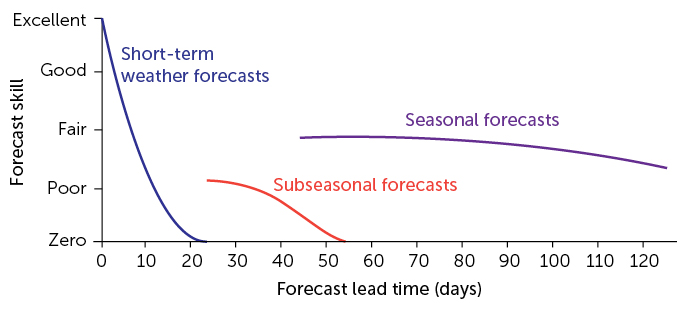
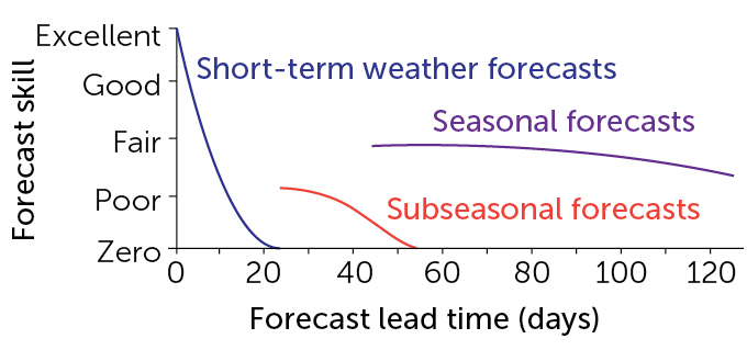
Such efforts, known as “subseasonal forecasting,” aim to fill a crucial gap in weather prediction. The approach fits between short-term forecasts that are good out to about 10 days in the future and seasonal forecasts that look months ahead.
A subseasonal forecast predicts average weather conditions three to four weeks away. Each day of additional warning gives emergency managers that much more time to prepare for incoming heat waves, cold snaps, tornadoes or other wild weather. Groups such as the Red Cross are starting to use subseasonal forecasts to strategize for weather disasters, such as figuring out where to move emergency supplies when it looks like a tropical cyclone might hit a region. Farmers look to subseasonal forecasts to better plan when to plant and irrigate crops. And operators of dams and hydropower plants could use the information to get ready for extra water that may soon tax the systems.
Subseasonal forecasting is improving slowly but steadily, thanks to better computer models and new insights about the atmospheric and oceanic patterns that drive weather over the long term. “This is a new frontier,” says Frédéric Vitart, a meteorologist at the European Centre for Medium-Range Weather Forecasts in Reading, England.
The in-between
Weather forecasters are always pushing to do better. They feed weather observations from around the world into the latest computer models, then wait to see what the models spit out as the most likely weather in the coming days. Then the researchers tweak the model and feed it more data, repeating the process again and again until the forecasts improve.
But anyone who tells you it will be 73° Fahrenheit and sunny at 3 p.m. four weeks from Monday is lying. That’s just too far out in time to be accurate. Short-term forecasts like those in your smartphone’s weather app are based on the observations that feed into them, such as whether it is currently rainy in Northern California or whether there are strong winds over central Alaska. For forecasting further into the future, what the rain or winds were like many days ago becomes less and less relevant. Most operational weather forecasts are good to about 10 to 14 days but no further.
A few times a year, forecasters draw up seasonal predictions, which rely on very different types of information than the current weather conditions that feed short-term forecasts. The long-term seasonal outlooks predict whether it will be hotter or colder, or wetter or drier, than normal over the next three months. Those broad-brush perspectives on how regional climate is expected to vary are based on slowly evolving planetary patterns that drive weather over the scale of months. Such patterns include the intermittent oceanic warming known as El Niño, the extent of sea ice in the Arctic Ocean and the amounts of moisture in soils across the continents.
Between short-term and seasonal prediction lies the realm of subseasonal prediction. Making such forecasts is hard because the initial information that drives short-term forecasts is no longer useful, but the longer-term trends that drive seasonal forecasts have not yet become apparent. “That’s one of the reasons there’s so much work on this right now,” says Emily Becker, a climate scientist at the University of Miami in Florida. “We just ignored it for decades because it was so difficult.”
A global impact
Part of the challenge stems from the fact that many patterns influence weather on the subseasonal scale — and some of them aren’t predictable. One pattern that scientists have been targeting lately, hoping to improve predictions of it, is a phenomenon known as the Madden-Julian Oscillation, or MJO.
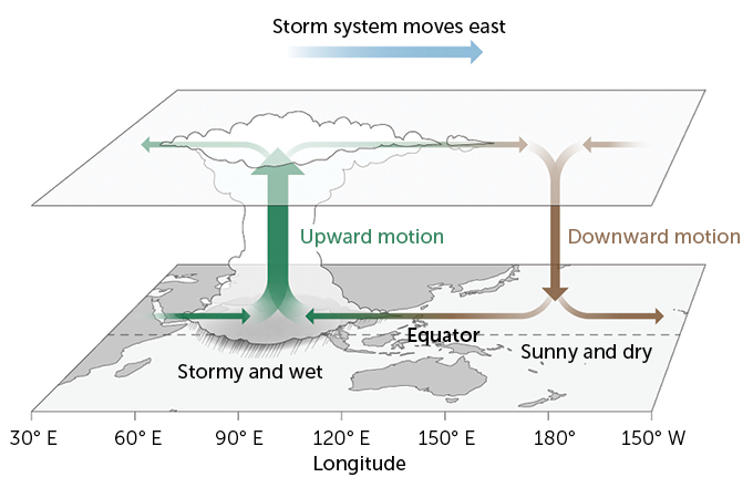
The MJO isn’t as well-known as El Niño, but it is just as important in driving global weather. A belt of thunderstorms that typically starts in the Indian Ocean and travels eastward, the MJO can happen several times a year.
An active MJO influences weather around the globe, including storminess in North America and Europe. Subseasonal forecasts are more likely to be accurate when an MJO is happening because there is a major global weather pattern that will affect weather elsewhere in the coming weeks.
But there’s still a lot of room for prediction improvement. The computer models that simulate weather and climate aren’t very good at capturing all aspects of an MJO. In particular, models have a hard time reproducing what happens to an MJO when it hits Southeast Asia’s mix of islands and ocean known as the Maritime Continent. This realm — which includes Indonesia, the Philippines and New Guinea — is a complex interplay of land and sea that meteorologists struggle to understand. Models typically show an MJO stalling out there rather than continuing to travel eastward, when in reality, the storms usually keep going.
At Stony Brook University in New York, meteorologist Hyemi Kim has been trying to understand why models fail around the Maritime Continent. Many of the models simulate too much light precipitation in the tropics, she found. That light drizzle dries out the lower atmosphere, contributing to the overly dry conditions favored in these models. As a result, when the MJO reaches the Maritime Continent, the dryness of most models prevents the system from marching eastward, Kim and colleagues reported in August 2019 in the Journal of Geophysical Research: Atmospheres. In real life, that rain doesn’t happen. With this better understanding of the difference between models and observations in this region, researchers hope to build better forecasts for how a particular MJO might influence weather around the world.
“If you can predict the MJO better, then you can predict the weather better,” Becker says. Fortunately, scientists are already making those tweaks, by developing finer-grained computer models that do a better job capturing how the atmosphere churns in real life.
Meteorologist Victor Gensini of Northern Illinois University in DeKalb led a recent project to use the MJO, among other factors, to forecast tornado outbreaks in the central and eastern United States two to three weeks in advance. As the MJO moves across and out of the Maritime Continent, it triggers stronger circulation patterns that push air toward higher latitudes. The jet stream strengthens over the Pacific Ocean, setting up long-range patterns that are ultimately conducive to tornadoes east of the Rocky Mountains. In the June Bulletin of the American Meteorological Society, Gensini’s team showed that it can predict broad patterns of U.S. tornado activity two to three weeks ahead of time.
High above the poles
Another weather pattern that might help improve subseasonal forecasts is a quick rise in temperature in the stratosphere, a layer of the upper atmosphere, above the Arctic or Antarctic. These “sudden stratospheric warming” events happen once every couple of years in the Northern Hemisphere and much less often in the Southern Hemisphere. But when one shows up, it affects weather worldwide. Shortly after a northern stratosphere warming, for instance, extreme storms often arrive in the United States.
In August 2019, one of these rare southern warmings, the largest in 17 years, began over the South Pole. Temperatures soared by nearly 40 degrees Celsius, and wind speeds dropped dramatically. This event shifted lower-level winds around Antarctica toward the north, where they raised temperatures and dried out parts of eastern Australia. That helped set up the tinder-dry conditions that led to the devastating heat and fires across Australia in late 2019 and early 2020 (SN: 2/1/20, p. 8).
Thanks to advanced computer models, forecasters at Australia’s Bureau of Meteorology in Melbourne saw the stratospheric warming coming nearly three weeks in advance. That allowed them to predict warm and dry conditions that were conducive to fire, says Harry Hendon, a meteorologist at the bureau.
Stratospheric warming events last for several months. As with an MJO, a subseasonal forecast made while one of them is happening tends to be more accurate, because the stratospheric warming affects weather on the timescale of weeks to months. Meteorologists call such periods “forecasts of opportunity,” because they represent times when forecasts are likely to be more skillful. It’s like how it’s easier to predict your favorite baseball team’s chances for the season if you know they’ve just hired the best free agent around.
A clearer picture
Now, researchers are pushing wherever they can to eke out improvements in subseasonal forecasts. The European forecast center where Vitart is based has been issuing subseasonal predictions since 2004, which have been improving with time. The U.S. National Oceanic and Atmospheric Administration began issuing similar predictions in 2017; they are not as accurate as the European forecasts, but have been getting better over time. Meanwhile, scientists have launched two big efforts to compare the various forecasts.
Vitart and Robertson lead one such project, under the auspices of the World Meteorological Organization in Geneva. Known as S2S, the meteorological shorthand for “subseasonal to seasonal,” the project collects subseasonal forecasts from 11 weather prediction agencies around the world, including the European center and NOAA. The forecasts go into an enormous database that researchers can study to see which ones performed well and why. Kim, for instance, used the database, among others, to understand why models have a hard time capturing the MJO’s march across the Maritime Continent.
The second effort, known as SubX, for the Subseasonal Experiment, uses forecasts from seven models produced by U.S. and Canadian research groups. Unlike S2S, SubX operates in nearly real time, allowing forecasters to see how their subseasonal predictions pan out as weather develops.
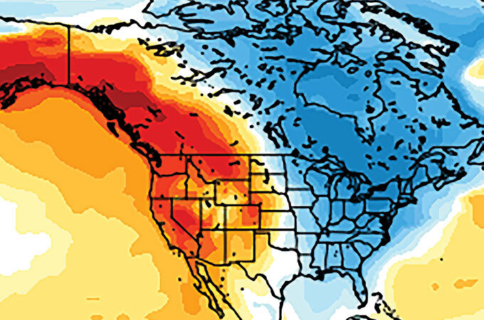
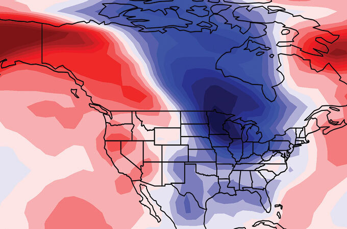
That proved useful in early 2019, when SubX forecasts foresaw, weeks before it happened, the severe cold snap that hit the United States in late January and early February. Temperatures dropped to the lowest in more than two decades in some places, and more than 20 people died in Wisconsin, Michigan and elsewhere.
Having an extra week’s heads-up that extreme weather is coming can be huge, Robertson says. It gives decision makers the time they need to assess what to do — whether that’s watering crops, moving emergency supplies into place or prepping for disease outbreaks.
In just one example, Robertson and colleagues recently developed detailed subseasonal forecasts of monsoon rains over northern India. He and Nachiketa Acharya, a climate scientist at Columbia University, described the work in January in the Journal of Geophysical Research: Atmospheres.
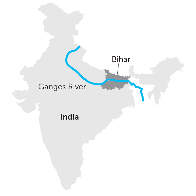
In 2018, the scientists focused on the Indian state of Bihar, where the regions north of the Ganges River are flood-prone and the regions to the south are drought-prone. Every week from June through September, the team worked with the India Meteorology Department in New Delhi to produce subseasonal rainfall forecasts for each of Bihar’s regions. The forecasts went to the state’s agricultural universities for distribution to local farmers. So when the summer monsoon rains arrived nearly 16 days later than usual, farmers were able to delay planting their rice and other crops until closer to the time of the monsoon, Acharya says. Such subseasonal forecasts can save farmers both time and money, since they don’t need to pay for irrigation when it’s not needed.
Acharya is now working with meteorologists in Bangladesh to develop similar subseasonal forecasts for that country. There the monsoon rains typically start around the second week in June but can fluctuate — creating uncertainty for farmers trying to decide when to plant. “If we can predict the monsoon onset by around the mid or end of May, it will be huge,” Acharya says.

Subseasonal forecasts can also help farmers improve productivity in regions such as western Africa, says Shraddhanand Shukla, a climate scientist at the University of California, Santa Barbara. He leads a new NASA-funded project that is kicking off to help farmers better time their crop planting and watering. The effort will combine satellite images of agricultural regions with subseasonal forecasts out to 45 days. If farmers in Senegal had such information in hand back in 2002, Shukla says, they could have better managed their plantings in the run-up to a drought that killed many crops.
As global temperatures rise and climate changes, meteorologists need to keep pushing their models to predict weather as accurately as possible as far in advance as possible, Vitart says. He thinks that researchers may eventually be able to issue forecasts 45 to 50 days in the future — but it may take a decade or more to get to that point. New techniques, such as machine learning that can quickly winnow through multiple forecasts and pinpoint the most accurate one, may be able to accelerate that timeline.
“There’s no single breakthrough,” Becker says. “But there are a lot of little breakthroughs to be made, all of which are going to help.”
from Science News https://ift.tt/2EoX26C


Comments
Post a Comment